Well Stratigraphy Data
Overview
The behaviour in version 3.0+ has improved significantly over version 2.x. Instructions for 2.x can be found toward the bottom of the page.
Version: 3.0+ (Mar 2026)
Usage: Borehole layer viewer/editor
How to use in practice
Stratigraphic data (lithostratigraphy and chronostratigraphy) are stored in the borehole to dynamically store formation top information which can then be applied to samples across a number of hierarchical stratigraphic levels.
Stratigraphic data in the borehole is split over four tabs; Lstrat, Alt Lstrat, Cstrat and Alt Cstrat. The behaviour of the Chronostratigraphy is similar to the Lithostratigraphy. Thus we will only concentrate on the use of the Lithostratigraphy here.
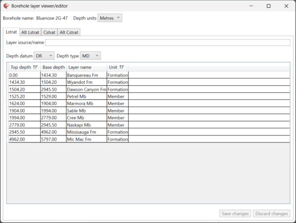
From version 2.0, two instances of stratigraphic tops can be stored in each borehole. We suggest using the Primary Lstrat for your active project tops, most likely from the latest (re-)interpretation within your company, and the Alternative Lstrat for any reference tops you wish to maintain, for example from a national authority. With each set of tops you can provide, and edit the source information to maintain the link to where the data came from.
From version 3.0 stratigraphy both the tops and the bases can be imported, viewed and edited.
Lithostratigraphic data can be added:
- Manually - using the Borehole layer viewer/editor
- Imported using an Excel import template
- Imported from an IGI well export file (.igi_well)
Manually populating lithostratigraphic data
Using the Borehole layer viewer/editor by right-clicking on a borehole. Create rows to receive the stratigraphy data and assign appropriate measurement datum’s and units. Highlight empty Lithostratigraphy rows and enter a Lithostratigraphy interval name, Top Depth, Base Depth and Unit if known (Group, Member, Formation) or if not leave as Unknown. Repeat for each interval.
Once entered select OK. At this point, with the well depth datum set and samples with their datum's assigned, information from the Lithostratigraphy tab will auto-populate both the Top Lstrat.Geol and the Base Lstrat.Geol properties (note the Group, Formation and Member level sample properties will also be set, if the Litho Unit is defined) where depth information is available.
Version: 2.0+ (Oct 2021)
Usage: Chronostratigraphy and Lithostratigraphy tabs in well artefact
How to use in practice
Stratigraphic data (lithostratigraphy and chronostratigraphy) are stored in the well artefact to dynamically store formation top information which can then be applied to samples across a number of hierarchical stratigraphic levels.
Stratigraphic data for the well is split over two well artefact tabs; Chronostratigraphy and Lithostratigraphy. The behaviour of the Chronostratigraphy is similar to the Lithostratigraphy tab. Thus we will only concentrate on the use of the Lithostratigraphy tab here.

From version 2.0, two instances of stratigraphic tops can be stored in each well. We suggest using the Primary Lstrat for your active project tops, most likely from the latest (re-)interpretation within your company, and the Alternative Lstrat for any reference tops you wish to maintain, for example from a national authority. With each set of tops you can provide, and edit the source information to maintain the link to where the data came from.
Stratigraphy is represented by tops only. This is because we assume there are no gaps in the stratigraphy, so the top of level below is the base of the level above. Where you have gaps in stratigraphy (possibly because the layer is unknown we advise adding in tops for specific unknown intervals. Where that is not appropriate, for example the case of a Member within a Formation with no member below, you must add an explicit Base element, for example "Base Petrel Mb" which will provide a lower boundary for that element. The name must be "Base XXXX" (or "Bottom XXXX") where "XXXX" is the name of the top.
Lithostratigraphic data can be added:
- Manually - using the Add/Edit Values... link at the bottom left of the tab
- Imported from an existing p:IGI-3 Well Manager file (.wmg)
- Imported using an Excel import template
- Imported from an IGI well export file (.igi_well)
Manually populating lithostratigraphic data

Using the Add/Edit Values... link at the base of the tab window, create rows to receive the tops data and assign appropriate measurement datum’s and units. Highlight empty Lithostratigraphy rows and enter a Lithostratigraphy interval name, Top Depth and Litho Unit if known (Group, Member, Formation) or if not leave as Unknown. Repeat for each interval. Manual entry is a little clunky at present - we advise bulk import.

Once entered select OK. At this point, with the well depth datum set and samples with their datum's assigned, information from the Lithostratigraphy tab will auto-populate both the Top Lstrat.Geol and the Base Lstrat.Geol properties (note the Group, Formation and Member level sample properties will also be set, if the Litho Unit is defined) where depth information is available.
© 2026 Integrated Geochemical Interpretation Ltd. All rights reserved.