The IGI property model
Overview
IGI's geochemical software (Metis and p:IGI+) contains a comprehensive industry-relevant property model. This page outlines key points and concepts of the IGI property model. This information relates to V3.0 of the software.
Usage: Throughout the system, particularly during import and interaction with the range of visualisation artefacts.
How to use in practice
Introduction
IGI's property model was created as a comprehensive and meaningful set of parameters that provide users with the ability to store data and associated metadata while also providing an appropriate schema against which efficient interpretation can take place.
The IGI property model overview
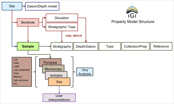
The IGI property model centres around a collected sample.

IGI Property Model Structure
There are some key domain concepts in the IGI property model:
- Sites - Information related to where the sample came from. This domain contains information such as (site location information (geographic/geologic) and datums.
- Boreholes - Information related to boreholes drilled at a given site. A site can have multiple boreholes linked to it. This domain contains information such as drilling information, stratigraphy tops and deviation paths.
- Samples - represent the concept of a quantity of material (solid, liquid or gas), which is analysed to measure one or more properties. A sample can be directly associated with a site or a site's borehole. In the case of the latter, deviation information and stratigraphic tops can be utilised to convert the sample measured depth to true vertical depth and provide stratigraphic labels, respectively.
- Analyses - empirical methods (often laboratory conducted) used to generate data. A sample will typically be subjected to one or more analyses, each measuring a range of properties. The type of analysis applied to a sample depends on the sample material, the analytical plan, and the available budget and equipment. The software supports an extensive set of analyses.
- Properties. Each analysis measures a series of physical/chemical properties of the sample material. Properties range from bulk characterisation of material to highly detailed molecular-isotopic compositional information.
- Units. Each measurement of a property typically results in either a string or a numerical value. When a numerical value is recorded, it is given a specific unit of measure to provide measurable context. The software supports a range of units and automatically converts between units where possible.
Understanding the IGI property model
To effectively use the IGI property model in p:IGI+ and Metis, it is necessary to understand some of the details of the model.
- Naming in the IGI property model. This explains the key concepts behind naming properties within p:IGI+ and Metis, as well as how to interpret the meaning of property names. In particular, this page introduces the concept of property indicators, which are used with molecular data to indicate whether the measurements are derived from heights, or areas from the chromatogram trace, or have been calculated as concentrations from heights or areas based on the injection of a known mass of an internal standard, or are of unknown origin.
- Units in the IGI property model. This page explains the unit system, and also why ratios are represented separately from units, but integrate with the unit system.
- "Any" properties in the IGI property model. This explains how we have provided a system to simplify the detailed property model during interpretation.
Note: There is a Geochemistry Help module available for the property model within the software. The dialogue is independent of the main p:IGI+ or Metis application and so can be kept open at all times for reference when needed.

Video tutorials
None Available
Return to the main User Guide page
© 2026 Integrated Geochemical Interpretation Ltd. All rights reserved.
